


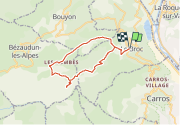
Mouton d'Anou par le Broc

GrouGary
User

Length
14.9 km

Max alt
1074 m

Uphill gradient
687 m
Km-Effort
24 km

Min alt
459 m

Downhill gradient
684 m
Boucle
Yes
Creation date :
2021-12-30 07:53:38.788
Updated on :
2021-12-31 13:19:07.93
4h43
Difficulty : Easy

FREE GPS app for hiking
 SityTrail
IGN / Geographical institutes
SityTrail Plus
The world is yours!
About
Trail Walking of 14.9 km to be discovered at Provence-Alpes-Côte d'Azur, Maritime Alps, Le Broc. This trail is proposed by GrouGary.
Description
Boucle tranquille pour journée d'hiver, exceptés les premiers 200m plus raides.
Belles vues Corse et Cap d' Antibes au sommet.
Photos


Positioning
Country:
France
Region :
Provence-Alpes-Côte d'Azur
Department/Province :
Maritime Alps
Municipality :
Le Broc
Location:
Unknown
Start:(Dec)
Start:(UTM)
352674 ; 4852357 (32T) N.
Comments